Mahābhārata begins with this introductory verse with the following meaning: – Having bowed down to Narayana and Nara, the best among men, and also to the goddess Saraswati, must the word Jaya be uttered. This is the first slōka (verse) in the first adhyāya (chapter) in the first Parva (book) of the Mahābhārata. (MBH.01.01.01).
nārāyaṇaṃ namaskṛtya naraṃ caiva narottamam
devīṃ sarasvatīṃ caiva tato jayam udīrayet
Mahābhārata is also the key to the revival of the Dharmic Civilization, as revealed in Ādi Parva (1st book), 56th adhyaya and 33rd slōka (MBH.01.56.33). This is also repeated in Swargārohana Parva, 5th adhyaya, and 38th slōka (MBH.18.05.38).
dharme cārthe ca kāme ca mokṣe ca bharatarṣabha
yad ihāsti tad anyatra yan nehāsti na tat kva cit
Dharma, Artha, Kāma, and Mōksha – O Bharatarshabha, on these, what is not discussed here is not discussed anywhere. In other words, one may find a discussion, description, or mention of Dharma, Artha, Kāma, or Mōksha in many other sources.
But all of them will be a copy or an extension of what is already discussed, described, or mentioned in the Mahābhārata. Mahābhārata is thus a complete reservoir of everything that is discussed or described by Dharma, Artha, Kāma, or Moksha.
Hence in the eventuality of complete disappearance of our Dharmic Civilization from the face of the earth, it can be still revived completely using the information contained in the Mahābhārata.
Going one more step ahead, not only the Dharmic Civilization with its philosophy and traditions can be revived, even the geography with its place-names can be renamed with the older names using the geographical data present in the Mahābhārata, as this paper is going to reveal.
Krishna Dwaipāyana Vyāsa the author of Mahābhārata, was the visionary behind a United Bhārata, which we now know as India. Vyāsa was a great scholar and ascetic in the Bhrigu lineage with the greats like Parāsara and Vasistha being his ancestors.
Vyāsa’s father Parasara was an astronomer and great grandfather Vasistha was a Vedic seer. Vyāsa classified the Vedic corpus into Rik, Yajus, Sama, and Atharva Vedas and earned the title Vyāsa, the classifier (of the Vedas). His own unique contribution, distinct from his forefathers was The Kurukshetra War narrative, designated as an Itihāsa (it happened thus).
This work was named as Jaya. Vyāsa’s knowledge of history, astronomy, and the geography of Bhāratavarsha got embedded into Jaya. Vyāsa thus seeded a growing knowledge repository in the form of Jaya. This war-narrative called Jaya had 8800 verses, structured as a dialog between Dhritarāshtra, the Kuru king, and his minister and aide Sanjaya.
Dhritarāstra’s sons participated in the war opposing the Pāndavas and Sanjaya witnessed it. Vyāsa, who fathered Dhritarāshtra turned this war-narrative dialog into an Itihāsa called Jaya.
This Jaya became Bhārata of 24,000 verses – structured as a dialog between Vyāsa’s disciple Vaiśampāyana and Janamejaya, the great-grandson of the Pāndava Arjuna. Bhārata then becomes Mahābhārata of 100,000 verses, structured as a dialog between Ugrasrava Sauti and sage Śhaunaka.
Jaya starts with astronomical observations and geographical analysis of Bhāratavarsha. Mahābhārata mentions every corner of Bhāratavarsha (which we now know as India) – its rivers, mountains, lakes, forests, and constituent provinces and kingdoms.
Mahābhārata is full of travel narratives showing how ancient people traveled across Bhāratavarsha connecting the places. Vyāsa is thus the real visionary behind a United Bhārata (much before the United India of 1947).
Mahābhārata is of 100,000 verses as revealed in this verse (MBH.01.56.13):- This consists of a hundred thousand shlokas composed by the son of Satyavati of pious deeds and of great mental power.
idaṃ śatasahasraṃ hi ślokānāṃ puṇyakarmaṇām
satyavaty ātmajeneha vyākhyātam amitaujasā
This is found to be true if we count the number of verses in currently available versions of Mahābhārata and Harivaṃśa together. Mahābhārata is having 84,879 verses and Harivaṃśa is having 16,374 verses, totaling 101,253 verses. I am using the Bengal edition of Mahābhārata for this verse count. Other editions to arrive at counts close to 100,000 verses.
The image is shown below (Figure 1) depicts the 18 books (parvas) of the Mahābhārata as a sphere with Harivaṃśa (the big blue sphere) in the background. Harivaṃśa is itself divided into three books (parvas) but is shown as a single sphere. The 18 Mahābhārata books are shown as spheres whose radius is proportional to the number of verses in each book.
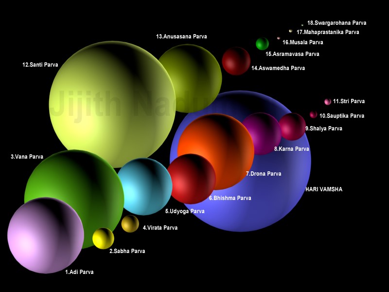
Figure 1: The 18 Mahābhārata Parvas and Harivaṃśa: A Size Comparison
The biggest book is Śanti Parva (12th book), the second biggest is Vana Parva (3rd book) and the third is Anusāsana Parva (the 13th book). These three books contain a lot of philosophical materials, debates, and conversations. The final books viz. the Musala Parva (16th book), the Mahāprastānika Parva (17th book), and the Swargārohana Parva (18th book) are the smallest Parvas.
Another way of comprehending the size of Mahābhārata is by comparing it with other Samskrit texts. The image is shown below (Figure 2) shows Mahābhārata in comparison with the four Vēdas, Rāmāyana, and the major Purānas. Iliad and Odyssey, the two Greek epics to are brought into comparison.
This gives an idea of the huge size of the Mahābhārata and also indicate the difficulty anyone will face when searching for information such as geographical data from the Mahābhārata. Skanda Purāna appear big but it includes all the multiple texts that claim to be Skanda Purāna
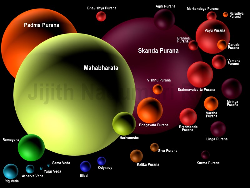
Figure 2: Mahābhārata in comparison with the Vēdas, Rāmāyana, Purānas and the Greek epics
Parts of Mahābhārata resemble the Vedic-Upanishadic corpus. Parts of Mahābhārata resemble the Puranic corpus. The core of Jaya is defined as an Itihāsa. Mahābhārata is thus a connecting link between Vedas and Purānas as indicated in this verse (MBH.01.56.15):- This is equal unto the Vēda, is holy and excellent; is the worthiest of all to be listened to, and is Purānam worshipped by the Rishis.
idaṃ hi vedaiḥ samitaṃ pavitram api cottamam
śrāvyāṇām uttamaṃ cedaṃ purāṇam ṛṣisaṃstutam
Itihāsa (thus it happened) is a more true description for Jaya which narrates the Kurukshetra war, as seen by an observer (viz. Sanjaya), than for the whole of Mahābhārata.
Thus we have in verse (MBH. 01.56.19): This Itihāsa is called Jaya. It should be heard by those desirous of victory. A king by hearing it may bring the whole world under subjection and conquer all his foes.
jayo nāmetihāso ‘yaṃ śrotavyo vijigīṣuṇā
mahīṃ vijayate sarvāṃ śatrūṃś cāpi parājayet
Geographical Data in Jaya
Since Vyāsa’s original work is Jaya, my first focus is to identify the geographical information confined within Jaya before exploring the rest of Mahābhārata. This exercise is to find out the oldest geographical data found in the Mahābhārata.
However, since we do not have the original Jaya but only the Jaya retold by Vaisampāyana and again retold by Sauti, we cannot guarantee that all of this data is absolutely the oldest.
Expansion from Jaya to Mahābhārata
The image below (Figure 3) shows the internal structure of the Mahābhārata. Of this, the inner core viz. Jaya, the Itihāsa, is a dialog between Dhritarashtra and Sanjaya, containing the eye witness account of the Kurukshetra War.
This is the original contribution of Vyāsa. It is approximately located between Bhishma Parva (6th book) and Sauptika Parva (10th book). It will not contain Vyāsa himself as a figure, unlike in the rest of Mahābhārata.
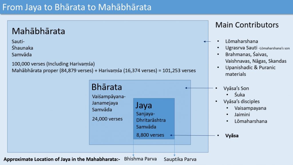
Figure 3: The internal structure of Mahābhārata with Bhārata and Jaya embedded in it
The next layer is Bhārata, which is a dialog between Janamejaya and Vaiśampāyana who narrates the Kurukshetra War and also the accounts of the births and lives of the Kauravas and the Pandavas and various other events in their lives leading to the war.
Janamejaya is the great-grandson of Arjuna who participated in the war and hence this narrative occurs 70 or more years after the war. Thus it is not a report of events as it happened before the eyes (Itihāsa) but an account of what is known from olden times (Purāna).
Vaisampāyana learned Jaya composed by his guru Vyāsa and retold it to Janamejaya with what else he knew about Kauravas, Pāndavas and Vyāsa resulting into the 24,000 verses of Bhārata.
Vyāsa’s Jaya is retold by Vaisampāyana and hence it is no longer available in its original form but as embedded and dissolved in Bhārata. Apart from Vaisampāyana, Vyāsa’s other disciples like Jaimini and Lōmaharshana and Vyāsa’s son Suka too is likely to have contributed to Bhārata.
This Bhārata is finally retold by Ugrasrava Sauti (who is the son of Vyāsa’s another disciple Lōmaharshana), probably after a few more years to an assemblage of sages at Naimisharanya headed by sage Saunaka. Hence Bhārata too is no longer available in its original form but as embedded and dissolved in Mahābhārata.
Since the Sauti too is mentioned in the third person in the Mahābhārata available to us, we must know that numerous other unknown contributors have added content to Mahābhārata. It contains materials identifiable with Saiva, Vaishnava, and Skanda Purānas.
It contains information about various orthodox Brahmanical practices. It contains the history of the Nāgas. It contains materials identifiable with the Vedas and Upanishads.
Based on the fact that Gautama Buddha (born in 563 BCE) is not mentioned in Mahābhārata, some scholars consider the currently available Mahābhārata as fully complete by 600 BCE while others maintain that it was continuously modified until the Gupta period (400 CE).
Kurukshetra War, which is the subject of Jaya is varyingly dated to 950 BCE (BB Lal), 1792 BCE (Bhatnagar), and 3067 BCE (Achar) of which 1792 BCE date is promising due to its coherence with archaeo-astronomy, architecture, and literature.
All these dates have a bearing on the geographical data found in the Mahābhārata, though dating is not the subject of this paper. For example a kingdom named Cīna (China) is mentioned in the Mahābhārata, which is connected with the Qin kingdom of China of 200 BCE.
Based on the travel narratives in the Mahābhārata, the kingdom Cīna is locatable to the north-east of Leh (mentioned as Lōha in Mahābhārata). This would either mean that the name Cīna entered into Mahābhārata at 200 BCE or the kingdom Qin of China migrated from the north-east of Leh and had the name Cīna before 600 BCE and Mahābhārata was the first text to mention it. Similarly, Mahābhārata mentions other foreign tribes like the Hunas, Khasas, Sakas, and Yavanas.
The start and end markers of Jaya
Since the original Jaya has dissolved into the Mahābhārata due to the retellings of Vaisampāyana and Sauti, we can only guess about the start and end markers of Jaya in the Mahābhārata. In the 2nd chapter of Bhīshma Parva (MBH.06.02.08) Vyāsa gives a boon to Sanjaya (saṃjayāya varaṃ dadau) to see the Kurukshētra War as it happens through his mind’s eye. Sanjaya then narrates it to Dhritarāshtra.
This can be taken as the start marker of Jaya. Similarly, in the 9th chapter of the Sauptika Parva (MBH.10.09.58) it is mentioned that soon after seeing the death of Duryōdhana, Sanjaya lost his divine vision (pranaṣṭaṃ tad divyadarśitvam). This can be taken as the end marker of Jaya. (Figure 4).
However, after giving the boon to Sanjaya, sage Vyāsa talks to Dhritarāshtra about the astronomical observations and other omens on the night before the start of the war.
This information is used by some archao-astronomers to date the start of the Kurukshētra War, like the famous observation of the stars Arundhati and Vasistha: – arundhatī tayāpy eṣa vasiṣṭhaḥ pṛṣṭhataḥ kṛtaḥ – (MBH.06.02.31).

The first words uttered by Sanjaya is from MBH.06.05.09 onwards (yathā prajñaṃ mahāprājña bhaimān vakṣyāmi te guṇān) as he starts speaking about the earth, its living beings, and its geography.
This can also be considered as the start-marker of Jaya. Geographical data in Jaya starts here. But in this case, the astronomical observations of Vyāsa which many scholars use to date the Kurukshētra War has to be treated as a preface to Jaya.
Another start-marker is found at MBH.06.14.03 where after returning from Kurukshētra Sanjaya reports the death of Bhīshma to Dhritarāshtra. Here Vaisampāyana mentions Sanjaya in 1st person.
saṃjayo ‘haṃ mahārāja namas te bharatarṣabha
hato bhīṣmaḥ śāṃtanavo bharatānāṃ pitāmahaḥ
If this is taken as the start-marker, both the astronomical data and the geographical data has to be treated as prefaces to Jaya. Going further the start of Bhagavat Gīta, where Dhritarārashtra asks Sanjaya about what happened in Kurukshētra where Kauravas and Pāndhavas are assembled, can also be treated as the start marker of Jaya at MBH.06.23.01:-
dharmakṣetre kurukṣetre samavetā yuyutsavaḥ
māmakāḥ pāṇḍavāś caiva kim akurvata saṃjaya
Finally the first word uttered by Sanjaya after the Bhagavat Gīta verses can be treated as the start-marker of Jaya, treating astronomical data, geographical data and the philosophical discourse (gīta) as the three prefaces to Jaya. This is at MBH.06.041.01:-
tato dhanaṃjayaṃ dṛṣṭvā bāṇagāṇḍīvadhāriṇam
punar eva mahānādaṃ vyasṛjanta mahārathāḥ
Going by the first definition viz. Sanjaya getting the boon of divine vision (saṃjayāya varaṃ dadau) as the start marker, we have the following structure of Jaya (Figure 5):
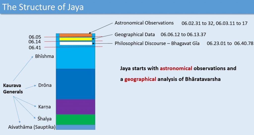
Figure 5: The structure of Jaya
Jaya is the narrative of the Kurukshētra war fought under the 5 generals (Bhīshma, Drōna, Karṇa, Śhalya, and Aśvathāma) of the Kuru army. Currently, in Mahābharata these appear as the five parvas of Bhīshma, Drōna, Karṇa, Śhalya, and Sauptika, which are the 6th, 7th, 8th, 9th, and the 10th books respectively. The observers were Sanjaya himself and probably the bards, spies, and confidants working under him on the battlefield.
Sanjaya narrated the war as observed by him and his accomplices to king Dhritarāshtra, which was then compiled into an Itihāsa kāvya named Jaya by Vyāsa. The concept of the boon of divine vision, which Vyāsa provided to Sanjaya, formed the necessary pretext to render the Itihāsa.
The whole Globe as Island Sudarsana
Bhīshma Parva, Jamvukānda Nirmāna Parva is an information-repository on the geography of Bhāratavarsha which also contains some rudimentary knowledge of the whole globe and the regions in Asia to the north of Bhāratavarsha. Pāndavas camped near Samantapanchaka for participating in the war.
Vaisampāyana says to Janamejaya: – Yudhishthira, the son of Kunti, caused tents by thousands to be set up according to rule, beyond the region called Samantapañchaka (samantapañcakād bāhyaṃ śibirāṇi sahasraśaḥ kārayām āsa vidhivat kuntīputro yudhiṣṭhiraḥ – MBH.06.01.06).
The forces fought in the Kurukshetra War was collected from the Jambūdvīpa region: – That area heated by the sun named Jambūdvīpa mandalam, from there, this force was collected, O best of king (yāvat tapati sūryo hi jambūdvīpasya maṇḍalam tāvad eva samāvṛttaṃ balaṃ pārthiva sattama – MBH.06.01.08).
Dhritarāshtra then says to Sanjaya: – Many heroic men have come to Kurujāṅgala. I want to hear the details of the countries and cities from which the warriors has come. Tell me about the rivers, mountains, provinces and forests.
MBH. 06.05.06
bahūni ca sahasrāṇi prayutāny arbudāni ca
koṭyaś ca lokavīrāṇāṃ sametāḥ kurujāṅgale
MBH. 06.05.07
deśānāṃ ca parīmāṇaṃ nagarāṇāṃ ca saṃjaya
śrotum icchāmi tattvena yata ete samāgatāḥ
MBH. 06.06.01
nadīnāṃ parvatānāṃ ca nāmadheyāni saṃjaya
tathā janapadānāṃ ca ye cānye bhūmim āśritāḥ
MBH. 06.06.02
pramāṇaṃ ca pramāṇajña pṛthivyā api sarvaśaḥ
nikhilena samācakṣva kānanāni ca saṃjay
Sanjaya mentions about a circular wheel-shaped Island named Sudarśana surrounded by the Salt Ocean. It is mentioned as reflected in the lunar disc. Two parts look like a Peepul tree and the other two look like a large hare (rabbit).
MBH.06.06.12
sudarśanaṃ pravakṣyāmi dvīpaṃ te kurunandana,
parimaṇḍalo mahārāja dvīpo ‘sau cakrasaṃsthitaḥ
lāvaṇena samudreṇa samantāt parivāritaḥ – MBH.06.06.14b
sudarśana dvīpo dṛśyate candramaṇḍale – MBH.06.06.15b
dvir aṃśe pippalas tatra dvir aṃśe ca śaśo mahān – MBH.06.06.16a
This Circular wheel-shaped Island named Sudarśana has a strong resemblance to the Polar Azimuthal Equidistant Projection of Globe. This projection was used by ancient Egyptians in connection with stellar maps. Textual record of its use by al-Biruni is attested in 11th century CE. Al-Biruni is a known scholar who studied/copied Indic knowledge.
This projection of the globe can be seen in the UN Emblem as well. It is possible that an ancient Polar Azimuthal Equidistant Projection of the world existed and this information got recorded in the Mahābharata through the words of Sanjaya.
In this projection, Antarctica will be shaped like a circular wheel. The two Peepul tree-shaped parts are Africa and South America and the two rabbit-shaped parts are Eurasia and North America.
Sanjaya being a layman (not a true geographer) sure has confused one of the rabbit-shaped parts (North America) with the rabbit-shaped dark mark on the moon.
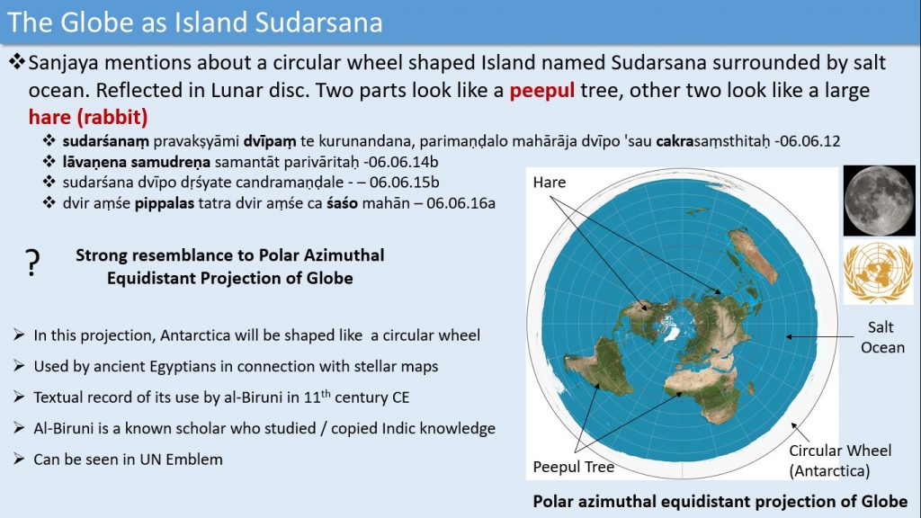
Figure 6: Circular wheel-shaped Island named Sudarśana, with a strong resemblance to the Polar Azimuthal Equidistant Projection of Globe
The Six Kula-Parvatas (Mountain Ranges) and the Seven Varshas (Regions)
Dhritarāshtra then asks Sanjaya to describe the portion resembling the rabbit in detail (MBH.06.07.01). This rabbit portion turns out to be Asia, especially the regions north of Bhāratavarsha up to the Arctic Ocean, containing mountain ranges spread in the east to west direction, like the Himālayas, the Kailāsa ranges, the Kunlun Shan mountains, the Tien Shan mountains, the Altai ranges, and the Sayan ranges.
Sanjaya names the six Kula-parvatas (mountain ranges) in the rabbit-shaped region spread in the east-west direction:
- Himavān
- Hemakūṭa – also known as Kailāsa
- Niṣadha
- Nīla – abounding with lapis lazuli – nīlaś ca vaiḍūryamayaḥ
- Śveta – white as the moon – śvetaś ca rajataprabhaḥ
- Śṛṅgavān – of all kinds of metals – sarvadhātuvinaddhaś ca śṛṅgavān
MBH.06.07.03
himavān hemakūṭaś ca niṣadhaś ca nagottamaḥ
nīlaś ca vaiḍūryamayaḥ śvetaś ca rajataprabhaḥ
sarvadhātuvinaddhaś ca śṛṅgavān nāma parvataḥ
These six mountain ranges divide the hare-portion into seven Varshas (regions)
- Bhārata Varsha – extreme south – bow-shaped
- Himavat Varsha
- Hari Varsha
- Ilāvrita Varsha – central Varsha
- Śveta Varsha
- Hiranyaka Varsha
- Airāvata Varsha – extreme north – bow-shaped
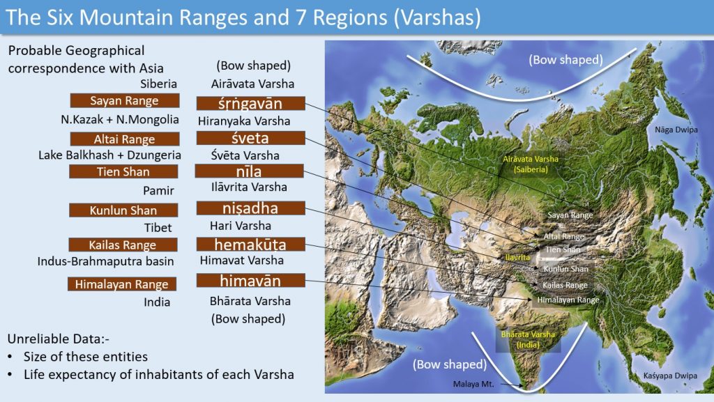
Figure 7: The Six Mountain Ranges and Seven Regions mapped to Asia
Figure 7 shows that there is a good correspondence between Sanjaya’s narratives of the six mountains and the seven regions to the mountains and regions of Asia, especially the bow-shaped southern region viz.
Bhārata Varsha (India) and the bow-shaped northern region Airāvata Varsha (Siberia). The relevant verses used for the identification are given below:
MBH.06.07.06
idaṃ tu bhārataṃ varṣaṃ tato haimavataṃ param
hemakūṭāt paraṃ caiva harivarṣaṃ pracakṣate
MBH.06.07.35
nīlotparataraṃ śvetaṃ śvetād hairaṇyakaṃ param
varṣam airāvataṃ nāma tataḥ śṛṅgavataḥ param
MBH.06.07.36
dhanuḥsaṃsthe mahārāja dve varṣe dakṣiṇottare
ilā vṛtaṃ madhyamaṃ tu pañcavarṣāṇi caiva ha
MBH.06.07.39
hemakūṭas tu sumahān kailāso nāma parvataḥ
yatra vaiśravaṇo rājā guhyakaiḥ saha modate
Bhārata Varsha (approximately the India of current times) is defined as the bow shaped region to the south of the Himālayas. The bow shape here is the reference to the shape of the peninsular India. The northern ranges of the Himālayas in Tibet is named as Hemakūta alias Kailāsa. In between these ranges is the valleys of Indus and Brahmaputra which is identifiable as the Himavat Varsha. Beyond Kailāsa / Hemakūta is Hari Varsha which is easily identifiable as Tibet.
The northern boundary of Tibet is the Kunlun mountain ranges (Kunlun Shan) which can be identified as the Nishadha Mountains. The mountain range to the north of Kunlun is the Tien Mountains (Tien Shan) which can be identified with the Nīla Mountains.
Between Tien Shan and Kunlun Shan is the Pāmir Mountains and the lowlands surrounding it, identifiable to the Ilāvrta region. Beyond Tien Shan in the north is the Altai Mountains, identifiable to the Śveta Mountains. The region between Tien Shan and Altai containing Lake Balkash and the Dzungeria valley is identifiable to the Śveta Varsha.
Beyond the Altai Mountains we have the Sayan Mountains containing the plains falling in Mongolia and Northern Kazakhstan which is identifiable with the Hiranyaka Varsha. The Sayan Mountains (identifiable Śṛṅgavān Mountains) form the southern boundary of Siberia (identifiable as the Airāvata Varsha).
Siberia too is bow shaped and fits perfectly well with the description given by Sanjaya. He says that the Varsha to the extreme south (i.e. Bhārata Varsha) and the Varsha of extreme north (i.e. Airāvata Varsha) are both bow-shaped (dhanuḥsaṃsthe mahārāja dve varṣe dakṣiṇottare -MBH.06.07.36). On the north of Sringavat and up to the margin of the sea, is the Airāvata Varsha (uttareṇa tu śṛṅgasya samudrānte janādhipa varṣam airāvataṃ nāma tasmāc chṛṅgavataḥ param – MBH.06.09.10).
There the sun gives no heat (na tatra sūryas tapati – MBH.06.09.11a). The moon with the stars are the only source of light there (candramāś ca sa nakṣatro jyotir bhūta ivāvṛtaḥ – MBH.06.09.11b).
The Arctic Ocean north of Siberia is described as the Milky Ocean, probably an eye witness account of the white-colored ice-sheets covering the Arctic Ocean (To its north is the Milky Ocean where resides Hari of Vaikuntha – kṣīrodasya samudrasya tathaivottarataḥ prabhuḥ harir vasati vaikuṇṭhaḥ śakaṭe kanakātmake- MBH.06.09.15).
The absolute and relative sizes of the Varsha’s mentioned in many thousand Yōjayas as well as the age of people living in each Varsha (running into many hundred years) are ignored as unreliable data. However, the complexion of people living there is mentioned as white which is an accurate description of the people living in these regions to the north of the Himālayas.
The color of the skin adapts to the low light conditions and become fairer in complexion. For an ancient traveler traveling from Bhārata Varsha to northern regions up to Siberia, crossing the six mountain ranges and also the lowlands and plains lying between them (viz. the Varshas) it will be difficult to accurately measure the size of the Varshas or to ascertain the age of the people living there.
Assuming that Sanjaya’s narrative is based on observation of such ancient travelers, we can reject the wild guesses on the size of the Varshas as well as the age of the people living in those regions.
Regarding the people inhabiting the six mountains, we have the following information. The Rākshasās live on the Himavat Mountains. The Yakshās (Guhyakas) live on the Hemakūta (Kailāsa) Mountains.
The Sarpās, Nāgās, and Gandharvās live on the Nishadha Mountains. The Brahmarshis live on the Nīla Mountains. Devās and Asuras live on the Śveta Mountains. The Pitris live on the Śṛṅgavān Mountains.
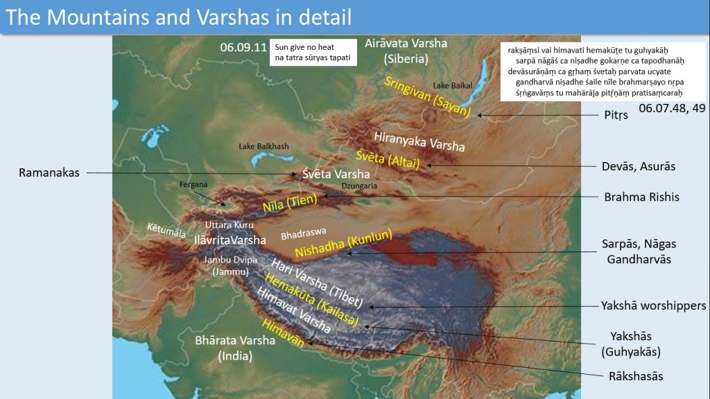
Figure 8: The Mountains and Varshas in detail with the names of inhabitants.
MBH.06.07.48
rakṣāṃsi vai himavati hemakūṭe tu guhyakāḥ
sarpā nāgāś ca niṣadhe gokarṇe ca tapodhanāḥ
MBH.06.07.49
devāsurāṇāṃ ca gṛhaṃ śvetaḥ parvata ucyate
gandharvā niṣadhe śaile nīle brahmarṣayo nṛpa
śṛṅgavāṃs tu mahārāja pitṝṇāṃ pratisaṃcaraḥ
Mahābhārata mentions about many Rākshasās like Ghatōtkacha living on the Himālayas. Hemakūta (Kailāsa) Mountains with its Yakshās lies in southern Tibet and the Nishadha Mountains (Kunlun Shan) with its Sarpās, Nāgās, and Gandharvās lies in northern Tibet forming its northern boundary.
Mahābhārata reveals that the Rākshasās, Yakshās, Gandharvās, and Nāgās were are genetically related tribes living on elevated mountains and plateaus. The culture of the Yakshās, Nāgās, and Gandharvās seems to have later given rise to the Tibetan culture.
The Brahmarshis seems to have chosen the secluded heights of the Nīlā Mountains (Tien Shan) as their abode, who are probably the figures revered in the Chinese culture as the gods. Tien Shan in Chinese means the mountain of heaven or the mountain of the gods.
The Dēvāsurās (Dēvās and Asurās) living on the Śveta Mountains (Altai Mountains) is indicative of an Indo-European migration hotspot in the Altai regions as they migrated from the Sarasvatī region. The name Airāvata given to Siberia is derived from the river name Irāvati (Rāvi River in Punjab).
One among the many Nāgā tribes mentioned in the Mahābhārata is Airāvata Nāgās described as living on the banks of Irāvati and Ganga rivers. They probably migrated to the Siberian region designating it as Airāvata.
Apart from the seven Varshas divided by the six mountains, in the rabbit-shaped dvīpā viz. Asia, two additional regions are mentioned by Sanjaya forming the two ears (karṇau) of the rabbit (śaśa) and lying adjacent (pārśve) to the two Varshas in the north and south (dakṣiṇottare), viz. Airāvata Varsha (Siberia) and Bhārata Varsha (India).
MBH.06.07.52
yāṃ tu pṛcchasi mā rājan divyām etāṃ śaśākṛtim
pārśve śaśasya dve varṣe ubhaye dakṣiṇottare
karṇau tu nāgadvīpaṃ ca kaśyapa dvīpam eva ca
They are the Nāga-dvīpā and Kaśyapa-dvīpā. These can be identified with the ear-shaped regions of Asia in North-East Asia and southeast Asia. North-East Asia with the Kamchatka peninsula in Russia can be identified as the Nāga-dvīpā and South East Asia with the Malaysian peninsula can be identified as the Kaśyapa-dvīpā.
The name Nāga-dvīpā, when assigned to the North East Asia, strengthens the probability of a Nāga migration from Siberia to Alaska giving rise to the northern native tribes of the Americas.
In human genome migration studies, the migration path of the M3 lineage originates close to the Irāvati River, pass through Airāvata (Siberia) and Nāgadvīpa (NE Asia), and finally reaches the Americas, supporting this assumption.
Sanjaya also describes the Malaya Mountains (the southern part of Sahya mountains in Kērala) separately as part of Asia (the rabbit-shaped island). Its peaks are described as having the hue of copper (tāmravarṇaḥ śiro rājañ śrīmān malayaparvataḥ etad dvitīyaṃ dvīpasya dṛśyate śaśasaṃsthitam – – MBH.06.07.53).
The Ilāvrta region in detail
Sanjaya has described the Ilāvrta region in more detail. In the Ilāvrta region, between the Nīla and Nishadha mountains lies the mountain Mēru.
Surrounding it are the four regions (Varshās) viz. Bhadrāśva, Ketumāla, Jambūdvīpa and Uttarakuru (tasya pārśve tv ime dvīpāś catvāraḥ saṃsthitāḥ prabho | bhadrāśvaḥ ketumālaś ca jambūdvīpaś ca bhārata | uttarāś caiva kuravaḥ kṛtapuṇyapratiśrayāḥ – MBH.06.07.11).
Uttarakuru is mentioned as lying to the north of Mēru and Ketumāla to the west of Mēru (meros tu paścime pārśve ketumālo mahīpate – MBH.06.07.29.a).
Bhadrāśva is mentioned as lying to the east – MBH.06.08.13). Jambūdvīpa alias Jambū khaṇḍa is mentioned as lying there itself (jambū khaṇḍaś ca tatraiva – MBH.06.07.29.b) implicitly to the south of Mēru.
We have already identified Mēru with the Pāmir Mountains. It is a mountain knot where many mountain ranges like Tien Shan (Nīla) and Kunlun Shan (Nishadha) joins with the Himalayas. Mountain ranges radiate from the Pāmir mountain complex in all four directions as shown in the figure below.
Bhadrāśva is then identifiable with the Tarim Basin to the east of Pāmir. Tarim River flows through this region. Kētumāla is identifiable with Tokharistan (Tushāra) on the banks of Oxus River (Amu Darya). It consists of the lowla
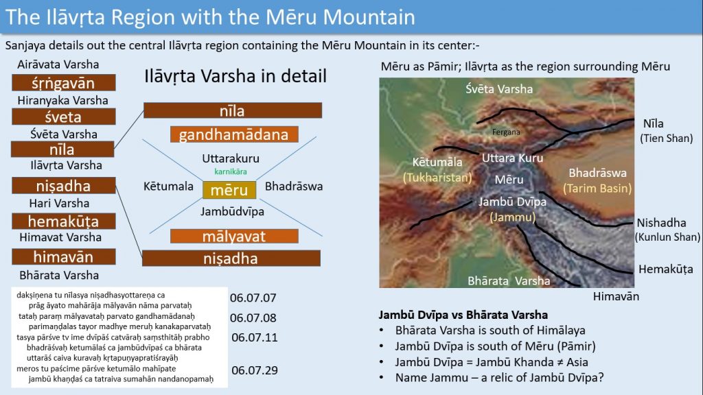
Figure 9: The Ilāvrta Varsha with Mēru Mountain in detail
plains to the west of the Pāmir mountain complex, lying now in northern Afghanistan, Turkmenistan, Uzbekistan and Tajikistan.
Regarding Uttara Kuru we have another verse (dakṣiṇena tu nīlasya meroḥ pārśve tathottare uttarāḥ kuravo rājan puṇyāḥ siddhaniṣevitāḥ – MBH.06.08.02). On the south of the Nīla Mountains and the northern side of Mēru are the sacred Uttara Kurus.
This Uttara Kuru is identifiable with the Alay Valley or the Fergana Valley. The identification of Uttara Kuru with Alay Valley is more suited if we consider the Alay Mountains to its north as part of the Nīla Mountains (Tien Shan).
The identification with of Uttara Kuru to Fergana Valley is appropriate if we consider the northern branch of Tien Shan (which is not connected to Pāmir but instead lies to the north of Fergana Valley) as the part of the Nīla Mountains. The Mahābhārata description of Nīla Mountains is not detailed enough to decide between these identifications.
Jambū Dvīpa is explicitly mentioned as lying near Mēru and implicitly to the south of Mēru. Since the whole of Ilāvŗta has to lie between Nishadha (Kunlun) and Nīla (Tien) Mountains, this has to lie somewhere in the southern part of the Pāmir mountain complex itself.
But the place names like Jammu indicates that this region extended to further south up to Jammu and hence included the Kashmir Valley.
There is another important point to note. The detailed description of Ilāvŗta with a central Mēru region and regions defined diagonally to the east, west, north, and south of Mēru is not fully in harmony with the description of the seven horizontal bands of Varshās and the six mountain ranges spread in the east-west direction. These two descriptions seem to have come from two different geographical data sources which Sanjaya apparently blended together.
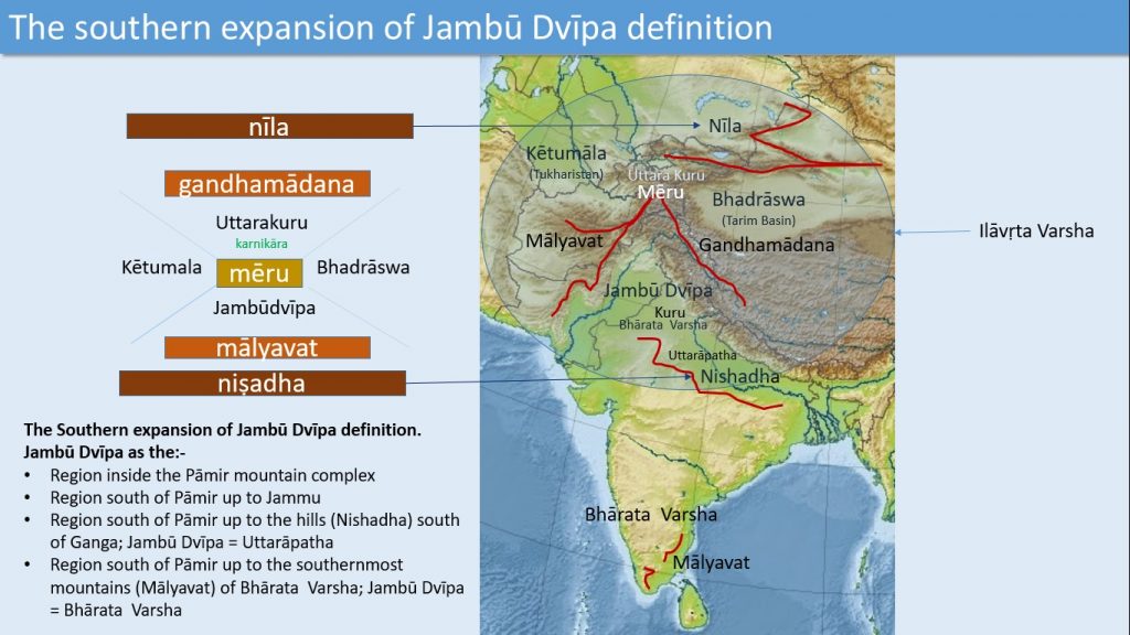
Figure 10: The southern expansion of the definition of Jambūdvīpā
In the Mahābhārata, the hilly terrain (around Gwalior) to south of Gangā river basin too is named Nishadha. In this different geographical data set with a central Mēru and four regions surrounding it, we have to redefine Nishadha Mountains with this hilly terrain forming the southern boundary of the Ganga river basin.
Then Jambūdvīpa can be defined as the regions to the south of Pāmir up to Ganga river basin, making it roughly same as what is later known as the Uttarāpatha region. The positioning of the two other mountains viz. Mālyavān and Gandhamādana near Mēru too fall in place with this redefinition of Nishadha.
Mālyavān is mentioned as lying to the south of Nīla and to the north of Nishadha (dakṣiṇena tu nīlasya niṣadhasyottareṇa ca prāg āyato mahārāja mālyavān nāma parvataḥ – MBH.06.07.07). Beyond Mālyavān is the Gandhamādana (tataḥ paraṃ mālyavataḥ parvato gandhamādanaḥ – MBH.06.07.08a).
Mēru is mentioned as a golden mountain between the Mālyavān and Gandhamādana Mountains (parimaṇḍalas tayor madhye meruḥ kanakaparvataḥ – MBH.06.07.08b). Gandhamādana is varyingly identified with today’s Karakoram Range and also with the Kailās Range. Mālyavān is varyingly identified with the Sulaiman range in West Pakistan and also with the southernmost mountains of India.
With the Mēru identified as Pāmir and Mālyavān identified as the southern mountains of India, Jambūdvīpa becomes roughly the same as Bhārata Varsha.
Many researchers have identified Jambūdvīpa with the whole of Asia. But as we have already seen Sanjaya has never named the Asian continent but described it as an unnamed region having the shape of a rabbit, complete with two ears.
We have also seen that Jambūdvīpa, in its expanded definition may be identified with Bhārata Varsha but in its restricted definition has to be identified
- within the Pāmir complex itself to the south of Pāmir (Mēru),
- with the regions to the south of Pāmir up to Jammu
- with the regions to the south of Pāmir up to the Gangā river basin (Uttarāpatha).
Probably the source of the confusion is the following verses defining a hypothetical Jāmbuvŗksha (Jāmbu-tree) to the south of Nīla and to the north of Nishadha. This gigantic tree is named Sudarśana, not to be confused with the circular wheel-shaped Island named Sudarśana representing the entire globe.
This tree has to be understood as the Pāmir / Mēru mountain complex where many mountain chains like the Mālyavān, Gandhamādana, Himālaya and Nīla (Tien Shan), branch off like the branches of a gigantic tree.
MBH.06.08.18
dakṣiṇena tu nīlasya niṣadhasyottareṇa tu
sudarśano nāma mahāñ jāmbūvṛkṣaḥ sanātanaḥ
MBH.06.08.18 is a duplicate of MBH.06.07.07 defining the location of Mālyavān Mountains to the south of Nīla and to the north of Nishadha.
MBH.06.07.07
dakṣiṇena tu nīlasya niṣadhasyottareṇa ca
prāg āyato mahārāja mālyavān nāma parvataḥ
Regions in the north: – Ramanaka and Hiranmaya
To the south of Śveta Mountains and to the north of the Nīla Mountains, a region named Ramanaka is mentioned making it synonymous to the Śveta Varsha (dakṣiṇena tu śvetasya nīlasyaivottareṇa tu | varṣaṃ ramaṇakaṃ nāma jāyante tatra mānavāḥ – MBH.06.09.02).
This can be identified as the Dzungeria valley, bounded by the Tian Shan (Nīla) mountain range to the south and the Altai (Śveta) Mountains to the north. Its inhabitants are of white complexion and of handsome features. This is also a hotspot of IE migrations from Sarasvatī and a probable location of people who migrated to Europe.
On the south of Śṛṅgivat and to the north of Śveta is the Varsha called Hiranmaya where is the river called Hiranwatī (dakṣiṇe śṛṅgiṇaś caiva śvetasyāthottareṇa ca | varṣaṃ hairaṇvataṃ nāma yatra hairaṇvatī nadī – MBH.06.09.05). Śṛṅgivat Mountain has three beautiful summits.
One is Maṇimayam (full of jewels) and another is Raukmam. There are houses on the mountain tops. The self-effulgent goddess Śāṇḍilī resides here (tatra svayaṃprabhā devī nityaṃ vasati śāṇḍilī – – MBH.06.09.09). Hiranmaya is thus synonymous to the Hiranyaka varsha mentioned before.
It is identifiable with the Great Lakes Depression in Western Mongolia, full of lakes and rivers, lying between the Sayan (Śṛṅgivat) Mountains in the north and the Altai (Śveta) Mountains in the south.
The Mountains of Bhāratavarsha
Dhŗtarāshtra asks Sanjaya to narrate Bhāratavarsha in detail. Sanjaya describes Bhāratavarsha as the beloved land of Indra and Vaivasvata Manu (atra te varṇayiṣyāmi varṣaṃ bhārata bhāratam | priyam indrasya devasya manor vaivasvatasya ca – MBH. 06.10.05) and many other rulers like Pṛthu, Vainya, Ikṣvāku, Yayāti, Ambarīṣa, Māndhātr, Nahuṣa, Mucukundasya, Śibi, Auśīnara and Ṛṣabha.
Then he explains the seven Kula-Parvatās (the major mountain ranges) of Bhāratavarsha. These are Mahendra, Malaya, Sahya, Śuktimān Ṛkṣavān, Vindhya and Pāriyātra (mahendro malayaḥ sahyaḥ śuktimān ṛkṣavān api vindhyaś ca pāriyātraś ca saptaite kulaparvatāḥ – MBH. 06.10.10).
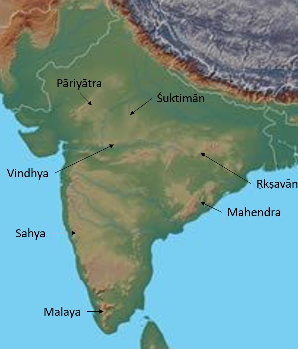
Figure 11: The Seven Kulaparvatās of Bhāratavarsha
Malaya Mountain is the southern part of Western Ghats in Kerala. The northern part of the Western Ghats to the north of Malaya is Sahya mountain range. The parts of the Eastern Ghats in Orissa is the Mahendra mountain range.
The mountains of Jharkhand is the Ṛkṣavān mountain range and the mountains of Bundelkhand is the Śuktimān mountain ranges, both to the south of Ganga river basin. The mountains to the north of Narmada is the Vindhya mountain ranges. The mountains in Rajastan currently known as the Aravalli range is the Pāriyātra mountain range.
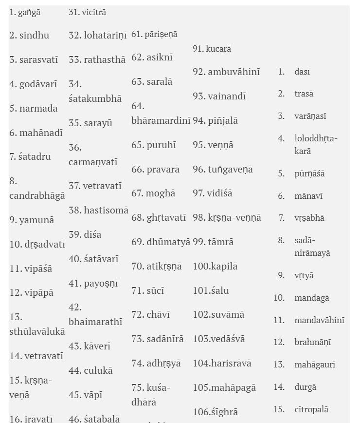
The Rivers of Bhāratavarsha
The data containing the names of the rivers of Bhāratavarsha is very dense and spread across 24 slōkas from MBH.06.10.12 to MBH. 06.10.35.
12 anye tato ‘parijñātā hrasvā hrasvopajīvinaḥ
āryā mlecchāś ca kauravya tair miśrāḥ puruṣā vibho
13 nadīḥ pibanti bahulā gaṅgāṃ sindhuṃ sarasvatīm
godāvarīṃ narmadāṃ ca bāhudāṃ ca mahānadīm
14 śatadruṃ candrabhāgāṃ ca yamunāṃ ca mahānadīm
dṛṣadvatīṃ vipāśāṃ ca vipāpāṃ sthūlavālukām
15 nadīṃ vetravatīṃ caiva kṛṣṇa-veṇāṃ ca nimnagām
irāvatīṃ vitastāṃ ca payoṣṇīṃ devikām api
16 veda-smṛtiṃ vetasinīṃ tridivām ikṣu-mālinīm
karīṣiṇīṃ citravahāṃ citrasenāṃ ca nimnagām
17 gomatīṃ dhūtapāpāṃ ca vandanāṃ ca mahānadīm
kauśikīṃ tridivāṃ kṛtyāṃ vicitrāṃ lohatāriṇīm
18 rathasthāṃ śatakumbhāṃ ca sarayūṃ ca nareśvara
carmaṇvatīṃ vetravatīṃ hastisomāṃ diśaṃ tathā
19 śatāvarīṃ payoṣṇīṃ ca parāṃ bhaimarathīṃ tathā
kāverīṃ culukāṃ cāpi vāpīṃ śatabalām api
20 nicīrāṃ mahitāṃ cāpi suprayogāṃ narādhipa
pavitrāṃ kuṇḍalāṃ sindhuṃ vājinīṃ puramālinīm
21 pūrvābhirāmāṃ vīrāṃ ca bhīmām oghavatīṃ tathā
palāśinīṃ pāpaharāṃ mahendraṃ pippalāvatīm
22 pāriṣeṇām asiknīṃ ca saralāṃ bhāramardinīm
puruhīṃ pravarāṃ menāṃ moghāṃ ghṛtavatīṃ tathā
23 dhūmatyām atikṛṣṇāṃ ca sūcīṃ chāvīṃ ca kaurava
sadānīrām adhṛṣyāṃ ca kuśa-dhārāṃ mahānadīm
24 śaśikāntāṃ śivāṃ caiva tathā vīravatīm api
vāstuṃ suvāstuṃ gaurīṃ ca kampanāṃ sa hiraṇvatīm
25 hiraṇvatīṃ citravatīṃ citrasenāṃ ca nimnagām
rathacitrāṃ jyotirathāṃ viśvāmitrāṃ kapiñjalām
26 upendrāṃ bahulāṃ caiva kucarām ambuvāhinīm
vainandīṃ piñjalāṃ veṇṇāṃ tuṅgaveṇāṃ mahānadīm
27 vidiśāṃ kṛṣṇa-veṇṇāṃ ca tāmrāṃ ca kapilām api
śaluṃ suvāmāṃ vedāśvāṃ harisrāvāṃ mahāpagām
28 śīghrāṃ ca picchilāṃ caiva bhāradvājīṃ ca nimnagām
kauśikīṃ nimnagāṃ śoṇāṃ bāhudām atha candanām
29 durgām antaḥśilāṃ caiva brahma-medhyāṃ bṛhadvatīm
carakṣāṃ mahirohīṃ ca tathā jambunadīm api
30 sunasāṃ tamasāṃ dāsīṃ trasām anyāṃ varāṇasīm
loloddhṛta-karāṃ caiva pūrṇāśāṃ ca mahānadīm
31 mānavīṃ vṛṣabhāṃ caiva mahānadyo janādhipa
sadā-nirāmayāṃ vṛtyāṃ mandagāṃ mandavāhinīm
32 brahmāṇīṃ ca mahāgaurīṃ durgām api ca bhārata
citropalāṃ citrabarhāṃ majjuṃ makaravāhinīm
33 mandākinīṃ vaitaraṇīṃ kokāṃ caiva mahānadīm
śuktimatīm araṇyāṃ ca puṣpaveṇy utpalāvatīm
34 lohityāṃ karatoyāṃ ca tathaiva vṛṣabhaṅginīm
kumārīm ṛṣikulyāṃ ca brahma-kulyāṃ ca bhārata
35 sarasvatīḥ supuṇyāś ca sarvā gaṅgāś ca māriṣa
viśvasya mātaraḥ sarvāḥ sarvāś caiva mahābalāḥ
The entire data when tabulated yields around 150 rivers.

The Provinces of Bhāratavarsha
The data containing the names of the provinces of Bhāratavarsha is similarly dense and is spread across 32 slōkas from MBH.06.10.37 to MBH. 06.10.68.
37 ata ūrdhvaṃ janapadān nibodha gadato mama
tatreme kurupāñcālāḥ śālva mādreya jāṅgalāḥ
38 śūrasenāḥ kaliṅgāś ca bodhā maukās tathaiva ca
matsyāḥ sukuṭyaḥ saubalyāḥ kuntalāḥ kāśikośalāḥ
39 cedivatsāḥ karūṣāś ca bhojāḥ sindhupulindakāḥ
uttamaujā daśārṇāś ca mekalāś cotkalaiḥ saha
40 pāñcālāḥ kauśikāś caiva ekapṛṣṭhā yugaṃ-dharāḥ
saudhā madrā bhujiṅgāś ca kāśayo ‘parakāśayaḥ
41 jaṭharāḥ kukkuśāś caiva sudāśārṇāś ca bhārata
kuntayo ‘vantayaś caiva tathaivāparakuntayaḥ
42 govindā mandakāḥ ṣaṇḍā vidarbhānūpavāsikāḥ
aśmakāḥ pāṃsurāṣṭrāś ca gopa-rāṣṭrāḥ panītakāḥ
43 ādi-rāṣṭrāḥ sukuṭṭāś ca balirāṣṭraṃ ca kevalam
vānarāsyāḥ pravāhāś ca vakrā vakrabhayāḥ śakāḥ
44 videhakā māgadhāś ca suhmāś ca vijayās tathā
aṅgā vaṅgāḥ kaliṅgāś ca yakṛl-lomāna eva ca
45 mallāḥ sudeṣṇāḥ prāhūtās tathā māhiṣa-kārṣikāḥ
vāhīkā vāṭadhānāś ca ābhīrāḥ kālatoyakāḥ
46 aparandhrāś ca śūdrāś ca pahlavāś carma-khaṇḍikāḥ
aṭavī śabarāś caiva maru-bhaumāś ca māriṣa
47 upāvṛścānupāvṛśca surāṣṭrāḥ kekayās tathā
kuṭṭāparāntā dvaidheyāḥ kākṣāḥ sāmudra-niṣkuṭāḥ
48 andhrāś ca bahavo rājann antargiryās tathaiva ca
bahirgiry āṅgamaladā māgadhā mānavarjakāḥ
49 mahyuttarāḥ prāvṛṣeyā bhārgavāś ca janādhipa
puṇḍrā bhārgāḥ kirātāś ca sudoṣṇāḥ pramudās tathā
50 śakā niṣādā niṣadhās tathaivānartanairṛtāḥ
dugūlāḥ pratimatsyāś ca kuśalāḥ kunaṭās tathā
51 tīragrāhāstara-toyā rājikā ramyakā-gaṇāḥ
tilakāḥ pārasīkāś ca madhumantaḥ prakutsakāḥ
52 kāśmīrāḥ sindhusauvīrā gāndhārā darśakās tathā
abhīsārā kulūtāś ca śauvalā bāhlikās tathā
53 darvīkāḥ sakacā darvā vātajāma rathoragāḥ
bahu-vādyāś ca kauravya sudāmānaḥ sumallikāḥ
54 vadhrāḥ karīṣakāś cāpi kulindopatyakās tathā
vanāyavo daśā pārśvā romāṇaḥ kuśa-bindavaḥ
55 kacchā gopāla-kacchāś ca lāṅgalāḥ paravallakāḥ
kirātā barbarāḥ siddhā videhās tāmraliṅgakāḥ
56 oṣṭrāḥ puṇḍrāḥ sa sairandhrāḥ pārvatīyāś ca māriṣa
athāpare janapadā dakṣiṇā bharatarṣabha
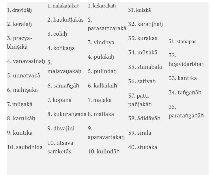
Southern Kingdoms
57 draviḍāḥ keralāḥ prācyā-bhūṣikā vanavāsinaḥ
unnatyakā māhiṣakā vikalpā mūṣakās tathā
58 karṇikāḥ kuntikāś caiva saubdhidā nalakālakāḥ
kaukuṭṭakās tathā colāḥ koṅkaṇā mālavāṇakāḥ
59 samaṅgāḥ kopanāś caiva kukurāṅgada māriṣāḥ
dhvajiny utsava-saṃketās trivargāḥ sarvasenayaḥ
60 tryaṅgāḥ kekarakāḥ proṣṭhāḥ parasaṃcarakās tathā
tathaiva vindhyapulakāḥ pulindāḥ kalkalaiḥ saha
61 mālakā mallakāś caiva tathaivāparavartakāḥ
kulindāḥ kulakāś caiva karaṇṭhāḥ kurakās tathā
62 mūṣakā stanabālāś ca satiyaḥ pattipañjakāḥ
ādidāyāḥ sirālāś ca stūbakā stanapās tathā
63 hṛṣīvidarbhāḥ kāntīkās taṅgaṇāḥ parataṅgaṇāḥ
uttarāś cāpare mlecchā janā bharatasattama
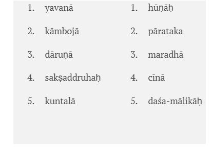
Northern Kingdoms
64 yavanāś ca sa kāmbojā dāruṇā mleccha jātayaḥ
sakṣaddruhaḥ kuntalāś ca hūṇāḥ pāratakaiḥ saha
65 tathaiva maradhāś cīnās tathaiva daśa-mālikāḥ
kṣatriyopaniveśāś ca vaiśyaśūdra kulāni ca
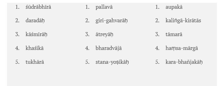
Non-kshatriya kingdoms
66 śūdrābhīrātha daradāḥ kāśmīrāḥ paśubhiḥ saha
khaśikāś ca tukhārāś ca pallavā girigahvarāḥ
67 ātreyāḥ sa bharadvājās tathaiva stanayoṣikāḥ
aupakāś ca kaliṅgāś ca kirātānāṃ ca jātayaḥ
68 tāmarā haṃsamārgāś ca tathaiva karabhañjakāḥ
uddeśa mātreṇa mayā deśāḥ saṃkīrtitāḥ prabho
When tabularized we get around 220 kingdoms or provinces which covers every portion of Bhāratavarsha.
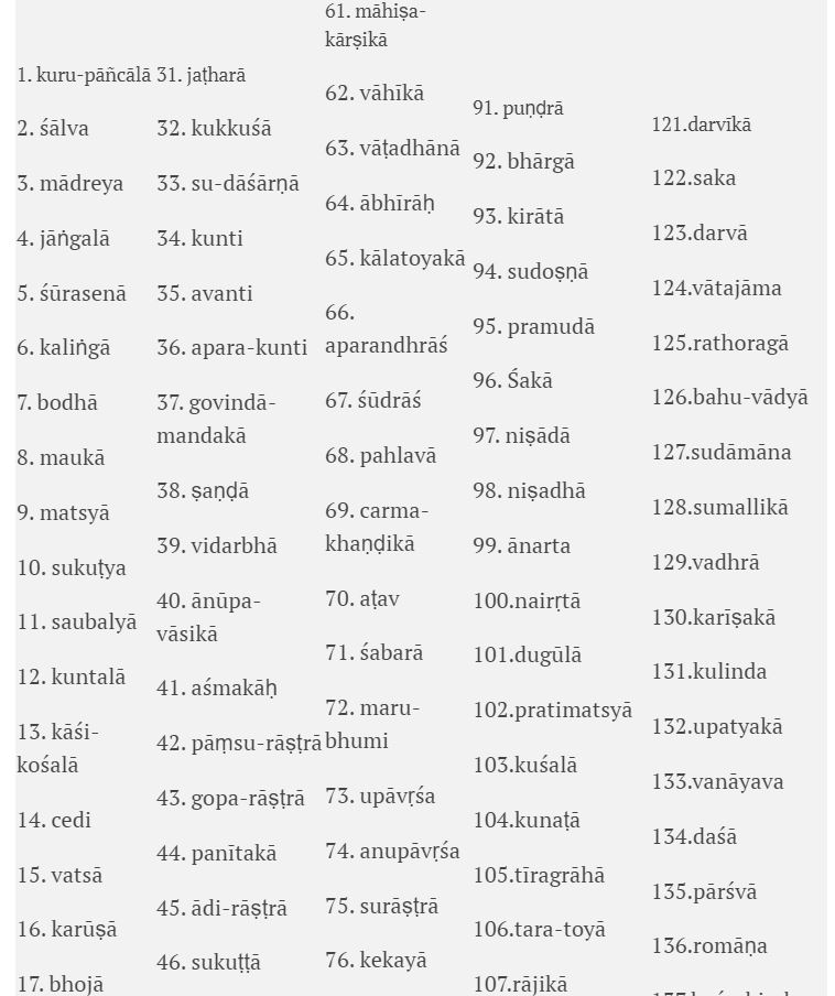
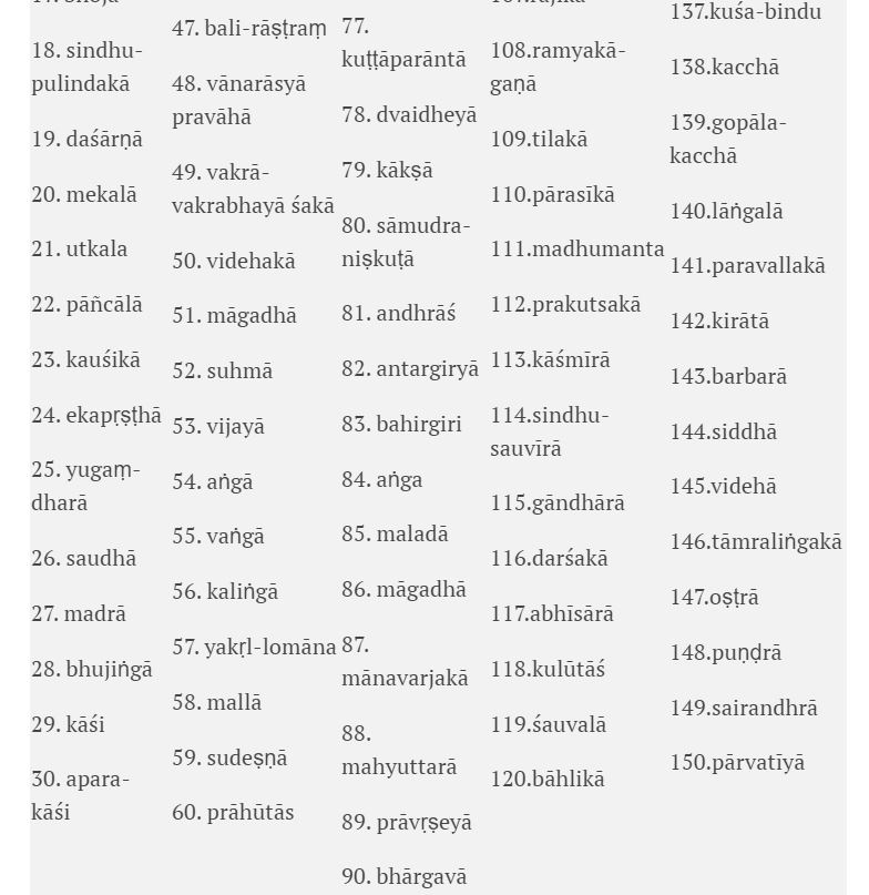
Around 150 provinces are mentioned first, then 45 southern provinces, 10 Northern provinces, and 15 provinces ruled by non-Kshatriya rulers are mentioned.
The Northern provinces:
The Southern provinces:
Provinces ruled by non-Kshatriya rulers:
To be continued…
The paper was presented as part of the Mahābhārata Manthan International Conference Delhi – July 19th to 21st, 2017.
Featured Image: Giampaolo Tomassetti
This paper was first published on India Facts.
Disclaimer: The facts and opinions expressed in this article are the personal opinions of the author. Indic Today does not assume any responsibility or liability for the accuracy, completeness, suitability, or validity of any information in this article.
Disclaimer: The opinions expressed in this article belong to the author. Indic Today is neither responsible nor liable for the accuracy, completeness, suitability, or validity of any information in the article.