
The Sarayu River, Ayodhya, Uttar Pradesh
कोशलो नाम मुदितः स्फीतो जनपदो महान्।
निविष्टः सरयूतीरे प्रभूतधनधान्यवान् ॥५॥
(On the banks of River Sarayu, a great and prosperous country named Kosala, abundant in food grains and wealth and inhabited by contended people, was situated.) ।।V.R.1.5.5।।
अयोध्या नाम नगरी तत्रासील्लोकविश्रुता।
मनुना मानवेन्द्रेण या पुरी निर्मिता स्वयम् ॥६॥
(In the country called Kosala was the famous capital city of Ayodhya built by the lord of men, Manu.) ।।V.R. 1.5.6।।
The Ramayana is often approached as a literary epic or spiritual symbol, but it is something more profound: a cultural map of ancient Jambudwipa. The epic composed by Sage Valmiki is not confined to mythical imagination; rather, it is deeply rooted in the rivers, mountains, forests, and cities that once shaped the reality of the Indian subcontinent.
To read the Ramayana is to follow a sacred journey that unfolds across thousands of kilometers; from the heartland of Ayodhya to the southern shores of Lanka. It’s more than just a myth; it’s a geographical memory, where legends along with landscapes intertwine to tell a story carved into the very terrain of the Jambudwipa.
Ayodhya and the Northwest
The epic begins in Ayodhya, the capital of Kosala, set on the banks of the Sarayu river. As described in Balakanda, Ayodhya is prosperous, orderly, immersed in dharma, and still holds its place as a spiritual heartland of Bharat. Archaeological excavations reveal a long history of continuous settlement, while the undying belief in the site as Ram’s birthplace remains unchanged.
However, after Ram’s exile, another geographical thread emerges – Bharata’s return from the Kekaya. In Ayodhyakanda (Sarga 70–71), Valmiki traces Bharata’s chariot route as he journeys from his maternal grandfather’s kingdom, likely near modern-day Afghanistan (Gandhar) or Chiniot-Pakistan, from Sudama River towards the Sutlej basin. He crosses rivers like the Shatādru (Sutlej) and the Hradini, possibly the Ghaggar-Hakra. He travels through Shalyakarshan (harsh terrain along present-day Punjab or Haryana), before entering the fertile Gangetic plains, witnessing a mournful return to Ayodhya.
This route, full of rivers, forests, and civil settlements suggests an ancient network of connectivity, detailed enough to reconstruct long-forgotten trade & travel routes.
From Chitrakoot to Dandakaranya
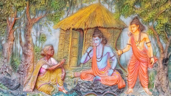
After the exile begins, Ram, Sita and Lakshman, visit Chitrakoot, a serene forested region on the border of contemporary Uttar Pradesh and Madhya Pradesh. According to Ayodhyakanda, the trio lived here peacefully. It’s where Bharata met Ram, urging his return. Today, Ram Ghat and Kamadgiri mark that sacred moment.
Thereafter, the exile deepens. The trio enter Dandakaranya, a vast and wild forest stretching across modern Madhya Pradesh, Chhattisgarh, Odisha and Maharashtra. This Dharmic land and its inhabitants were haunted by demons. Valmiki’s descriptions resonate with the tribal and forested geography that still defines the region today. It was a battlefield between good and evil, action and restraint.
Panchavati: The turning point
The next significant stop is Panchavati, near today’s Nashik (Maharashtra) on the banks of the Godavari. Named after five sacred trees, this is where the narrative escalates. Shurpanakha appears, Ravana is summoned and Sita is abducted. What began as a tranquil residence, transformed into a pursuit across the subcontinent. Even now, Sita Gufa and the Godavari ghats preserve the memory of that cosmic rift.
Kishkindha: Sugriva’s World Survey
Ram’s search leads him to Kishkindha, the kingdom of the vanaras, often identified with Hampi (Karnataka). With its rocky terrain, the Tungabhadra River and Anjanadri Hill (believed to be Hanuman’s birthplace), Hampi mirrors the epic’s landscapes. It is here that Ram forms his alliance with Sugriva, stepping towards the final act.
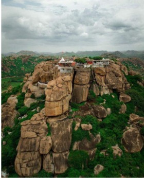
(Figure 1: Anjanadri Hills, Hampi, Karnataka)
Then comes one of the most remarkable passages in the Ramayana: Sugriva’s geographical brilliance and fourfold dispatch. In Kishkindhakanda (Sarga 40–43), Sugriva lays out a detailed map of the known and unknown world, sending his armies to the four cardinal directions taking Aryavarta as the centre in search of Vaidehi.
The Eastern Survey (Sarga 40)
एवमुक्तस्तु सुग्रीवो विनतं नाम यूथपम्। अब्रवीद् रामसांनिध्ये लक्ष्मणस्य च धीमतः ॥
शैलाभं मेघनिर्घोषमूर्जितं प्लवगेश्वरम्। सोमसूर्यनिभैः सार्धं वानरैर्वानरोत्तम ॥ १७ ॥
देशकालनयैर्युक्तो विज्ञः कार्यविनिश्चये । वृतः शतसहस्रेण वानराणां तरस्विनाम् ॥ १८ ॥
अधिगच्छ दिशं पूर्वा सशैलवनकाननाम्। तत्र सीतां च वैदेहीं निलयं रावणस्य च ॥१९॥ मार्गध्वं गिरिदुर्गेषु वनेषु च नदीषु च।
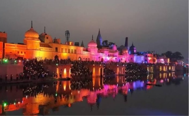
(Figure 2: Ayodhyā and the timeless Sarayū )
When Sugriva sends his vanaras eastward in search of Sita, the Ramayana briefly opens up like a scroll of ancient geography. Led by Vinata, the search party moves through regions like Videha, Kashi, Magadha and Pundra, following sacred rivers; the Ganga, Sarayu, Yamuna, and the now-vanished Saraswati. These rivers weren’t just water bodies—they carried the rhythms of Vedic life and sacred tradition.
The vanaras are told to look beyond the mainland—to islands and eventually Mount Udaya, where the sun is said to rise. This journey blends real places with cosmic imagination, even describing strange beings like one-footed tribes and tiger-headed men.
कर्णप्रावरणाश्चैव तथा चाप्योष्ठकर्णकाः। घोरलोहमुखाश्चैव जवनाश्चैकपादकाः ॥२६॥
अक्षया बलवन्तश्च तथैव पुरुषादकाः। किरातास्तीक्ष्णचूडाश्च हेमाभाः प्रियदर्शनाः ॥२७॥
आममीनाशनाश्चापि किराता दीपवासिनः। अन्तर्जलचरा घोरा नरव्याघ्रा इति स्मृताः ॥२८॥
एतेषामाश्रयाः सर्वे विचेयाः काननौकसः।
(Those who have ears hanging down to their feet like garments (Karnapravarana), those whose ears extend up to their lips (Oshthakarnika), and the terrible iron-faced beings whose countenances are dark and fearsome like iron; those who, though having only one leg, move with great speed, and whose lineage never declines; and those powerful man-eating Rākṣasas; those Kirātas whose topknots are sharp like the point of a needle, who shine like gold, are pleasing in appearance, eat raw fish, dwell on islands, and move about within the waters; and those dreadful creatures whose lower form resembles a human while the upper form is like that of a tiger — O monkeys! You should go to the abodes of all these beings and search there for Sita and Ravana.) ॥२६-२८ १/२॥
Along the way, the Bhagirathi and the Shona rivers are mentioned—both flowing through present-day Bihar. They’re not just landmarks, but clues to how ancient Indians saw their world: as sacred and interconnected.
The path continues to Mt. Mandara, known in myth for the Samudra Manthan, and possibly linked to Bihar’s Mandar Hill. Further east, Sugriva speaks of Jatarupashila, “golden-hued mountain” – possibly inspired by the mineral-rich regions of Southeast Asia. Scholars have speculated that this might be an ancient Indic memory of Paracas Candelabra due to its geographical similarities. Mentions of Rupyaka Island, Suvarnadvipa (Sumatra) and Yavadvipa (Java) suggest an early awareness of lands beyond the Indian coast.
He also mentions Shalmali-dvipa—a mystical island with a giant Shalmali tree and a temple built by Vishvakarma for Garuda. Some even wonder if this was a symbolic memory of a faraway land like the Americas, imagined long before they were known.
The Southern Expedition (Sarga 41)
नीलमग्निसुतं चैव हनूमन्तं च वानरम्। पितामहसुतं चैव जाम्बवन्तं महौजसम्॥२॥ सुहोत्रं च शरारिं च शरगुल्मं तथैव च। गजं गवाक्षं गवयं सुषेणं वृषभं तथा ॥३॥ मैन्दं च द्विविदं चैव सुषेणं गन्धमादनम् । उल्कामुखमनङ्गं च हुताशनसुतावुभौ ॥४॥
अङ्गदप्रमुखान् वीरान् वीरः कपिगणेश्वरः ।
वेगविक्रमसम्पन्नान् संदिदेश विशेषवित्॥५॥
(Hanuman, Angada, and Jambvanth take the southern route—a path that grows wilder and more mysterious with every step. Starting from the Vindhya range, they descend into the thick forests below, crossing the Narmada and moving alongside sacred rivers like the Godavari, Mahanadi, Krishna, and Kaveri. These rivers guide them through the heart of ancient India, weaving through present-day Maharashtra, Telangana, Andhra Pradesh, and Tamil Nadu.)
विदर्भानृष्टिकांश्चैव रम्यान् माहिषकानपि ॥१०॥
तथा वङ्गान् कलिङ्गांश्च कौशिकांश्च समन्ततः । अन्वीक्ष्य दण्डकारण्यं सपर्वतनदीगुहम् ॥११॥
नदी गोदावरीं चैव सर्वमेवानुपश्यत । तथैवान्ध्रांश्च पुण्ड्रांश्च चोलान् पाण्ड्यांश्च केरलान् ॥१२॥
(In the same way, after thoroughly searching everywhere in the regions of Vidarbha, Rishtika, the delightful land of Mahishika, Vanga, Kalinga, and Kaushik, you should investigate the entire Dandakaranya together with its mountains, rivers, and caves. There, in the Godavari River, search repeatedly on every side. Likewise, search also in the regions of Andhra, Puṇḍra, Chola Kingdom, Pandya Kingdom, and Kerala.)
Sugriva directs them through Mahishaka, a land thought to lie between the Godavari and Krishna, likely aligning with parts of modern Karnataka and Andhra. As they go deeper, familiar names from classical Tamilakam appear—Chola, Pandya, Andhra, and Kerala, regions already rich in culture and identity, even in early narration of the epic.
अयोमुखश्च गन्तव्यः पर्वतो धातुमण्डितः । विचित्रशिखरः श्रीमांश्चित्रपुष्पितकाननः ॥१३॥
सुचन्दनवनोद्देशो मार्गितव्यो महागिरिः ।
Their journey leads to the Malaya Mountains, often identified with the Western Ghats. Somewhere within this range lies Ayomukha, the “iron-faced” peak that marks the frontier of the known world in Ramayana’s imagination.
Finally, they reach the Kaveri River, a sacred stream flowing through Tamil Nadu to the sea. This sacred southern trail culminates near today’s Rameshwaram, where land meets ocean and where Ram, too, would soon stand, ready to cross into Lanka. Sugriva even hints at lands beyond—Pushpitaka and Sūryavanta—mysterious realms that blur the line between distant continents and spiritual frontiers.
The Western Survey (Sarga 42)
अथ प्रस्थाप्य स हरीन् सुग्रीवो दक्षिणां दिशम् ।
अब्रवीन्मेघसंकाशं सुषेणं नाम वानरम्॥१॥
तारायाः पितरं राजा श्वशुरं भीमविक्रमम्।
(After dispatching the monkeys toward the southern direction, King Sugriva approached the monkey-chief named Suṣeṇa — the father of Tara and his own father-in-law.”)
Susena leads the westward group through Saurashtra, Bhīma, Bāhlīka, and Sindhu territory, passing arid deserts and coastal lines. They cross mountains like Hemagirī and Chakravantha, before arriving at Mount Meru and Ashtadri, marking the farthest western limit.
सौराष्ट्रान् सहबालीकांश्चन्द्रचित्रांस्तथैव च ॥ स्फीताञ्जनपदान् रम्यान् विपुलानि पुराणि च। पुंनागगहनं कुक्षिं बकुलोद्दालकाकुलम् ॥७॥ तथा केतकषण्डांश्च मार्गध्वं हरिपुङ्गवाः।
(O best of monkeys! Search for Sita in the regions of Saurashtra, Bāhlīka, and Candracitra, as well as in other prosperous and delightful countries and great cities; also in the land of Kukṣi, which is filled with punnāga, bakula, and uddālaka trees, and in the forests of ketaka (screw-pine).) (॥६-७ १/२॥)
The Northern Survey (Sarga 43)
ततः संदिश्य सुग्रीवः श्वशुरं पश्चिमां दिशम्।
वीरं शतबलिं नाम वानरं वानरेश्वरः ॥१॥
(Shatbali’s party heads into the Himalayas, encountering Mlecchas, Pulindas, Kuru-Panchala, Kambhoja, and Cheena (China). They traverse sacred peaks–Kailash, Hemagarbha, Krouchagiri and reach the northern ocean.)
तत्र म्लेच्छान् पुलिन्दांश्च शूरसेनांस्तथैव च। प्रस्थलान् भरतांश्चैव कुरूंश्च सह मद्रकैः ॥११॥
काम्बोजयवनांश्चैव शकानां पत्तनानि च। अन्वीक्ष्य दरदांश्चैव हिमवन्तं विचिन्वथ ॥१२॥
(In the north, after thoroughly searching the lands and cities of the Mlecchas, Pulindas, Shurasena, Prasthala, Bharata (the regions around Indraprastha and Hastinapura), Kuru (the southern Kuru land around Kurukṣetra), Madra, Kamboja, the Yavanas, and the Śakas, search further in the land of Darada and upon the Himalayas.)
ततः सोमाश्रमं गत्वा देवगन्धर्वसेवितम्। कालं नाम महासानं पर्वतं तं गमिष्यथ ॥१४॥
Beyond the known world, Sugriva mentions a mysterious place called Somagiri, a mountain said to lie where the moon rises, covered in snow and filled with sacred energy. It’s not a place ordinary people can reach. Some believe it symbolizes the spiritual unknown—the edge of the map where only the divine can go. Others think it might even hint at real places like the polar regions or Antarctica. Either way, it shows that the Ramayana wasn’t just about physical geography, but also about exploring deeper cosmic and moral realms.
From Rameshwaram to Lanka: The Sacred Bridge
Ram’s army eventually reaches Rameshwaram, at the southern tip of India. Here, the vanaras build the legendary Setu Bandhanam—a bridge of floating stones. Whether one interprets this as a miracle or metaphor, satellite imagery has revealed a submerged causeway, Ram Setu, connecting Dhanushkodi to Mannar Island. Faith and science converge in quiet mystery.
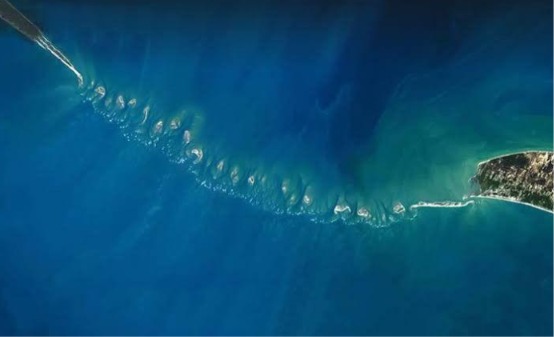
(Figure 3: ISRO satellite image of Ram Setu)
Across the strait lies Lanka, often identified with Sri Lanka, particularly Trincomalee. The Ramayana paints it as a city of gold, echoing with grandeur and arrogance. Archaeological evidence may be inconclusive, but the cultural memory endures.
The Sacred Terrain
What makes the geography of the Ramayana so compelling is that it is never passive. Rivers like the Sarayu, Godavari, and Tungabhadra are not just routes but witnesses. Forests like Dandakaranya are not just wild rather, arenas of dharma. Mountains, caves, trees – all are saturated with sacred memory.
The proposed Ramayana Circuit, developed by the Indian government, seeks to connect these spaces physically. But for pilgrims, these routes have existed for millennia, walked through tirtha-yatra, carried in oral tradition and devotional memory.
A Sacred Map
As scholars like Dr. B.B.Lal and S. Balakrishna have pointed out, Valmiki’s Ramayana isn’t a wild leap through fantasy– it’s a grounded, step-by-step journey through real places known to ancient India. Many of its locations align with archaeological findings and cultural memory, revealing how deeply the epic is rooted in actual history.
Today, modern tools like satellite imagery, underwater surveys, and age-old place names only deepen our understanding of this sacred geography. Reading the Ramayana is like walking through Bharatāvarsha itself, not just in myth, but in soil and stone. It’s a cosmic tale, yes – but also a cultural map, tracing a path of dharma that spans the subcontinent, from the banks of the Sarayu to the shores of Lanka.
To follow Ram’s journey, whether through books or on foot–is to move through a landscape where every river carries a story, and every hill holds a memory.
References
- Valmiki Ramayana, trans. Bibek Debroy (Penguin) & Gita Press editions https://archive.org/details/shrimad-valmiki-ramayana-hindi-edition-valmiki/page/n1267/mode/1up
- B.B. Lal, Rama: His Historicity, Mandir and Setu
- S. Balakrishna, Geography of Ramayana, Ramayana Centre
- Meenakshi Jain, The Battle for Rama
- R. Nagaswamy, Foundations of Indian Culture
- Archaeological Survey of India Reports on Hampi, Ram Setu & Dandakaranya
- Ministry of Tourism, Govt. of India – Ramayana Circuit Project
- NASA & ISRO satellite studies – Ram Setu.
- Jatland Wiki – Somagiri
Disclaimer: The opinions expressed in this article belong to the author. Indic Today is neither responsible nor liable for the accuracy, completeness, suitability, or validity of any information in the article.